Diagrams of the crash
|
|
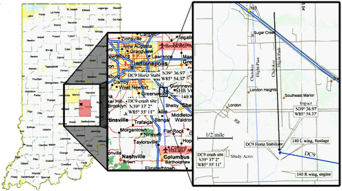
| A map of the crash site. I know it's small, but I don't need it to take any longer to load than it already does! In the panel at right, the vertical blue line is the intended flight path of the Cherokee. He is about 1/4 mile off to the east, which is astoundingly accurate dead-reckoning flying. The vertical black line is his actual flight path, and the DC9 comes in from the southeast along the heavy blue line. Locations where the pieces landed are marked; the body of the DC9 continued over to the west, in the bottom left corner of the panel. |
Here are two animated GIFs:
The first shows the two aircraft converging on each other in a
top view. It is correct for the relative sizes, speeds, and convergence angle of the two aircraft involved. Note
how little time the crews would've had to see each other, and how, by the time they're right in each other's sights,
it's absolutely too late to do anything! How unlucky an accident, in that mere tenths
The second shows the last one-and-a-half seconds before impact, as seen form the Cherokee. Note the "blossom" effect, and just exactly how little time you have to react. (This GIF is about a half a meg, and takes a while to load. Please be patient!)
As a pilot, I will tell you that it is easy to not spend every second looking outside for traffic. In the case of this accident, the pilots really would've only become aware of each other with about 3 or 4 seconds to react, regardless of their diligence in scanning. This is not enough time to react successfully, and therefore, the NTSB ruling of "no fault". (No fault on the crews, that is. The poor radar coverage and lack of regulations requiring transponders for all aircraft were ultimately given the blame. This is little consolation for those who were killed.)
Anyway, the pilot of the DC-9 was still on instruments, having just emerged from the cloud layer. The copilot was by regulation giving altitude calls so as not to bust the clearance down to 2500' they'd been given. The Cherokee pilot was doing an impeccable job of keeping his track. He had passed the point where the straight-line path between Brookside and Bakalar diverged from the road he could have been following (thereby cheating on his heading hold), and at the time of impact, he was so close to the flight-planned path, that had it been a huge line drawn on the ground, he would've been unable to see it by leaning to each side of the cockpit and straining to see as far underneath him as possible! He must have been holding his heading within a degree or so, and had his wind correction down perfectly. All this precision, before GPS! We'll never know, but he may even have been using the mobile home park as a checkpoint!
This attention to detail on your flight path is not unusual for an advanced student pilot, and if it, along with the positive comments made by his family and flight instructor, is true, it is a strong indication that he was a fine pilot. Even with the good outside scan he must've had going, though, the time it took him to glance down at his chart for a quick (and totally normal) postition check would've been enough to allow the jet to converge on him.
Truly a no-fault accident.
Here is a sample of what Mr. Carey's flight plan may have
looked like. I've added the line at impact (I doubt he would've planned that), and I've extrapolated the time of
departure back from the CVR tape time of the crash, using the winds from the time of the crash and fuel burn, climb
rate, and cruise speeds typical of a student cross-country in a 140.